The short answer
A block plan is a to-scale drawing of your whole plot from above, showing the house, existing buildings, the garden room and the distance from it to every boundary. The law asks for an identified scale and a north point. Councils usually ask for 1:500 or 1:200. A location plan is the separate map that shows where the plot sits.
A block plan is the drawing a council reads first. It is short, it is flat, and it answers the questions that matter for a garden room: where does it sit, how close is it to the boundary, and is anything else already on the plot. Get it wrong and the application waits while someone asks you to redraw it.
What a block plan is, and how it differs from a location plan
Two drawings, two jobs
A block plan is a to-scale view from above of your plot, with the house, any extensions, existing sheds and outbuildings, and the new garden room, each with the distances to the boundaries. A location plan is a different drawing: a map on an up-to-date Ordnance Survey base, usually at 1:1250 or 1:2500, with the site edged in red and any other land you own edged in blue. The location plan says where. The block plan says how close.
Why the council wants both
The location plan lets the council find the plot. The block plan lets it check the room against the limits. For a garden room that means the height limits near a boundary, the front wall line and the 50% coverage limit in Class E of the General Permitted Development Order, all of which turn on where things sit on the plot.
Scale: 1:500 or 1:200
Councils usually ask for 1:500 or 1:200 on a block plan. That is the common practice rather than the wording of the law, and your council’s own validation list has the final say, so look it up before you print.
At 1:200, 1 mm on the sheet is 20 cm on the ground, which is detailed enough to read a distance off the plan. At 1:500 the same millimetre is 50 cm, which suits a long plot that would not fit at 1:200. Pick the larger scale your sheet can hold.
North point and stated scale are the legal minimum
What the law does say is short. For a certificate of lawfulness of proposed use or development, article 39(2)(a) of the Development Management Procedure Order for England asks for a plan identifying the land, “drawn to an identified scale and showing the direction of North”. Wales has the same wording in article 28. For a planning application, article 7(2) in England and article 5(2) in Wales say plans must be drawn to an identified scale and show the direction of north. A plan with no scale and no north point fails that test before anyone reads the distances.
Scotland and Northern Ireland have their own procedure orders and their own council validation lists. Read your council’s before you draw.
What it must show for a garden room
The legal minimum gets the plan accepted. A useful block plan carries what the limits turn on.
The plot, house, extensions and existing buildings
Draw the whole plot with its boundaries, the house, any extension, and every building already standing in the garden, with sheds, greenhouses and summerhouses included. Class E limits the ground covered by buildings in the curtilage, other than the original house, to 50% of the curtilage, excluding the original house’s footprint. The council cannot test that without seeing what is already there. There is more on the sum in garden room size without planning permission.
The room and its roof edge, not just the walls
Show the room’s footprint and the edge of its roof. The technical guidance (page 43) says that if any part of the building is within 2 metres of the boundary of the curtilage, the height limit for the whole building drops to 2.5 metres. The guidance defines a building as including any part of a building, so a roof that overhangs the wall can pull the room into the zone when the wall alone would stay outside it. Our sample sheet has the roof edge 120 mm beyond the walls and draws it.
Distance to every boundary and the 2 m zone
Mark the distance from the room to each boundary, measured to the roof edge, and show the 2 metre line. That is the number the height limit hangs on. The full rule is in the garden room height limits, and the block plan is where you prove which side of it you are on.
The front wall line
Class E does not permit any part of the building on land forward of a wall forming the principal elevation of the original house. Show the front of the house and the line through it, so the council can see the room sits behind it. The rule sits with the others in Class E outbuildings, limit by limit.
Limit
Measure to the roof edge
A distance taken from the wall to the fence can look safe while the roof edge sits closer than 2 metres. Measure to the nearest part of the building.
Five things that get a block plan sent back
These are common problems rather than a count of refusals, and each one is easy to fix before you send.
- No scale bar. A plan that is printed, scanned or shrunk to fit a screen stops matching its stated ratio. A scale bar shrinks with the drawing, so the reader can still measure from it.
- Wall-to-fence instead of roof-edge-to-fence. The 2 metre zone is tested against any part of the building, so the roof edge is the figure to give.
- Existing sheds missing. The coverage sum needs every building in the curtilage. Leave the old shed off and the total does not add up. See garden room size without planning permission.
- The boundary drawn from memory. A fence is not always on the boundary line. Draw the boundary from the location plan or your deeds, and if you measure to the fence, say so on the sheet.
- No north point. It is one of the two things the orders ask for by name, and the cheapest to forget.
Our sample sheet, annotated
The sheet is sheet 2 of 4 in the drawing pack, and you can see the whole pack on the sample drawings page. It is the block plan for a 4.00 m x 3.00 m flat-roofed garden office in an England back garden, drawn at 1:200 at A3.
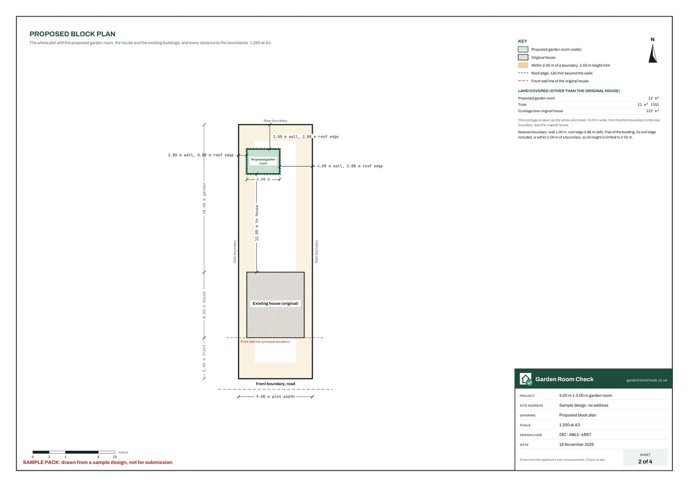
What is on it:
- The whole plot with the house, the existing buildings and the room.
- The room’s distances to the boundaries, wall and roof edge each given: on the left boundary the wall is 1.00 m away and the roof edge 0.88 m, and at the rear the wall is 3.00 m away and the roof edge 2.88 m.
- The roof edge drawn 120 mm beyond the walls.
- The 2 metre boundary zone, and a note that because part of the building is inside it, the height is limited to 2.50 m.
- The front wall line.
A note on the sheet carries the result in words, so the reader does not have to find it on the drawing.
Can you draw your own?
Yes. Nothing in the orders says an architect must draw a block plan: it must be to an identified scale, show north, and be accurate. If you can measure the plot and draw to scale, you can do it yourself, starting from your Ordnance Survey location plan.
The slow part is the checking, since every distance has to come off the plan to the roof edge and match your other drawings. The free 3D check tests your design against the limits first. The £49 supporting report and block plan is drawn from that design, and the £99 drawing pack adds the floor and roof plan and the elevations for a Lawful Development Certificate or a householder application. Drawing services usually quote per job, often from several hundred pounds.
Your council decides. The check shows how the design reads against the rule, and the block plan is how you show it. To see where this drawing fits in the whole certificate, read the Lawful Development Certificate guide and the householder application guide.
Sources
Every number in this guide that does not come from our own 3D check was checked against these 4 documents, numbered in the order the text first cites them and read between 11 November 2026 and 18 November 2026. 4 are legislation and government guidance.
- 1legislation.gov.ukThe Town and Country Planning (Development Management Procedure) (England) Order 2015: application contents, notices, ownership certificates, certificate applications
- 2legislation.gov.ukThe Town and Country Planning (Development Management Procedure) (Wales) Order 2012, articles 5, 10, 11 and 28
- 3legislation.gov.ukThe Town and Country Planning (General Permitted Development) (England) Order 2015, Schedule 2, Part 1, Class E (legislation.gov.uk, revised text)
- 4GOV.UKPermitted development rights for householders: technical guidance (MHCLG, September 2019), pages 6 to 13 and 41 to 46